OFFICIAL DESCRIPTION CHANGE
OFFICE: Research and Analytics
EFFECTIVE DATE: 7-8-2016
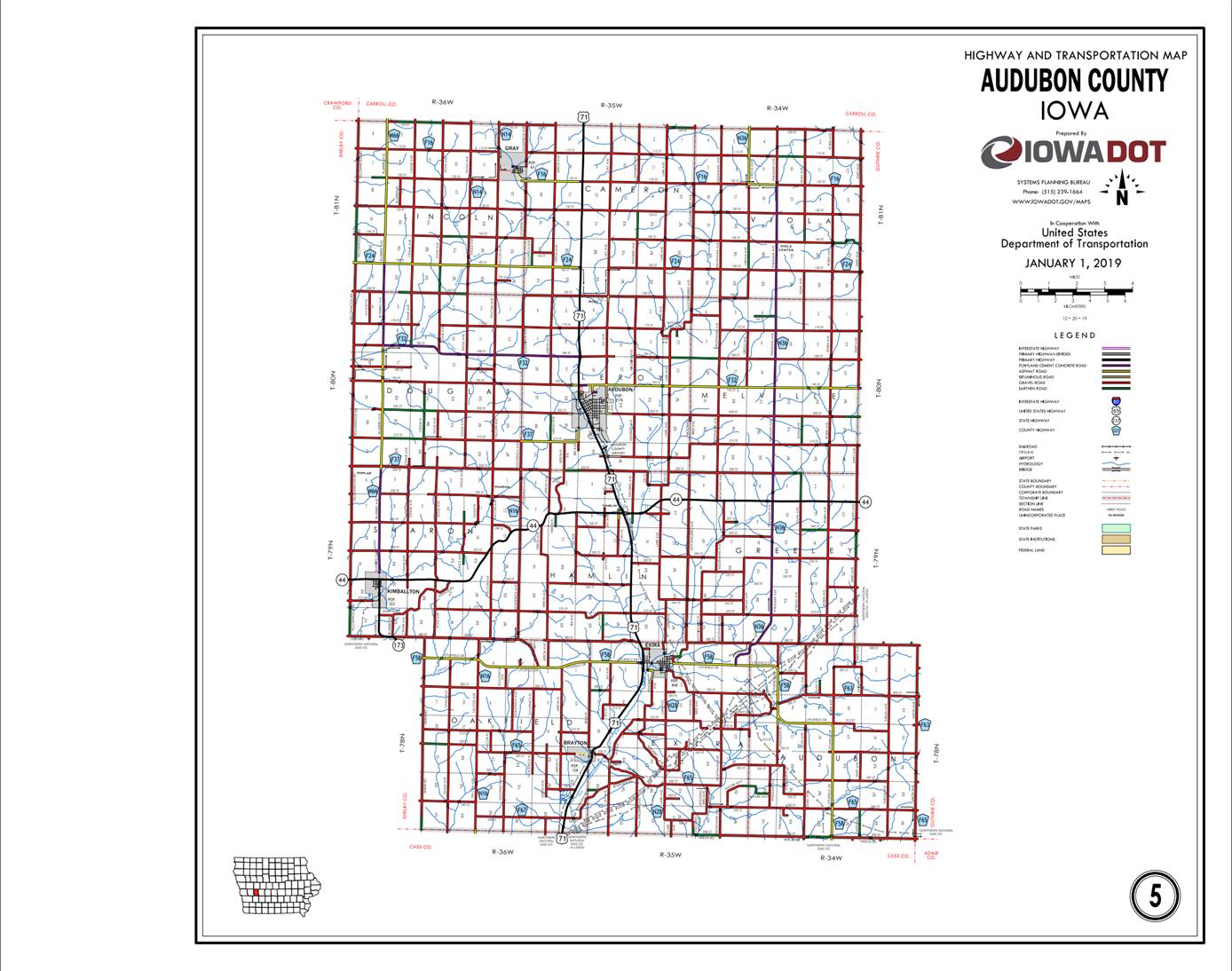
COUNTY: Audubon
ROUTE: US 71
ENTERED BY: Paul Mauer
ENTERED DATE: 1-29-2020
New
Description ‑ US 71 and its extensions in
Beginning
on the Audubon‑Cass County line at a point approximately 600 feet east
of the SW Corner of Section 16‑T78N‑R36W, Audubon County (NW Corner
of Section 1‑T77N‑R36W, Cass County); thence in a northeasterly
direction through Sections 36, 25, and 24‑T78N‑R36W and Section 19‑T78N‑R35W
to the south corporation line of Brayton connecting with Lincoln Street.
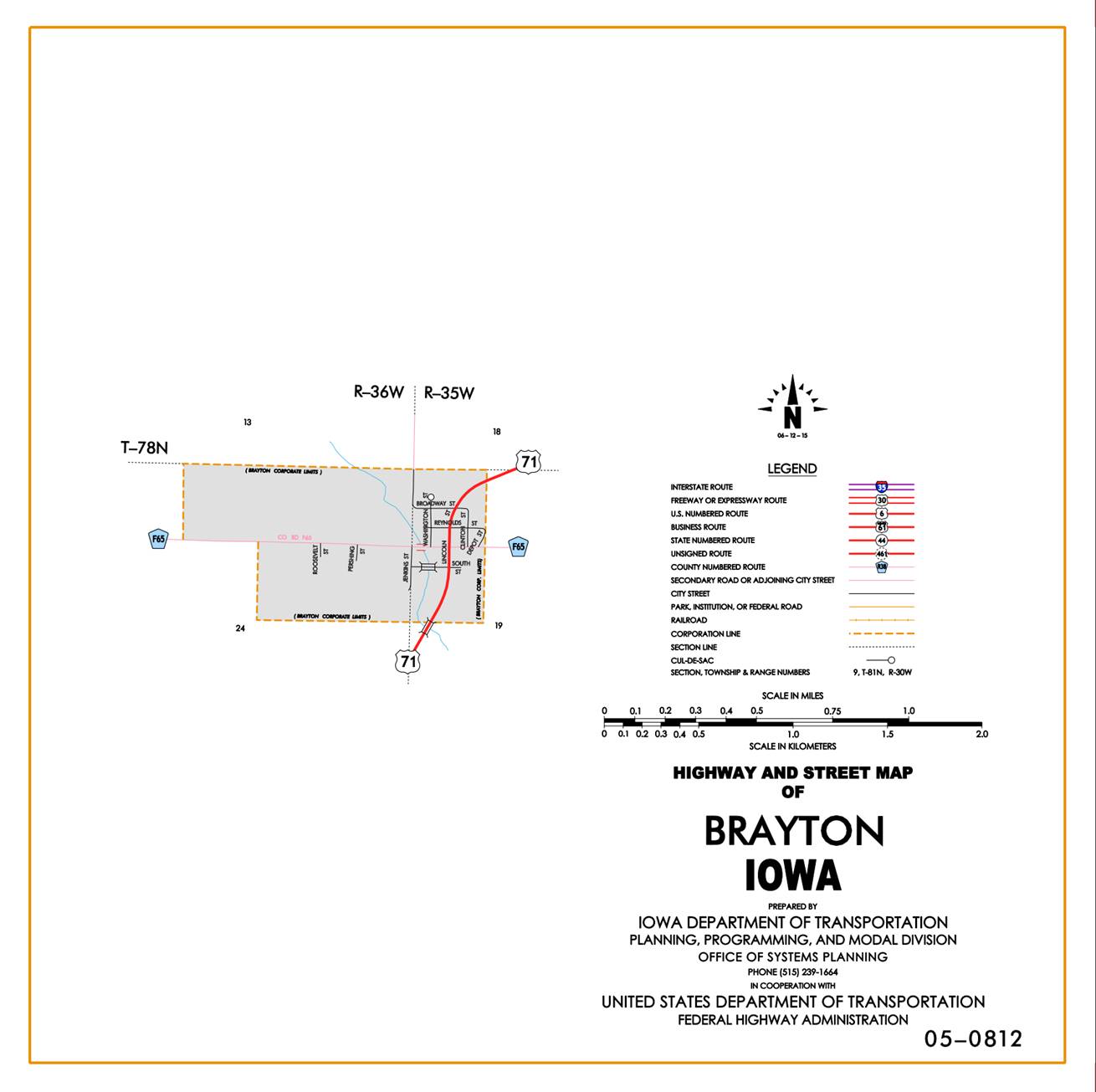
Brayton:
Beginning
on the south corporation line connecting with
Beginning
again on the north corporation line of Brayton connecting with Lincoln Street;
thence in a northeasterly direction through Sections 19, 16, 17, 8, 5, and 4‑T78N‑R35W
to the south corporation line of Exira.
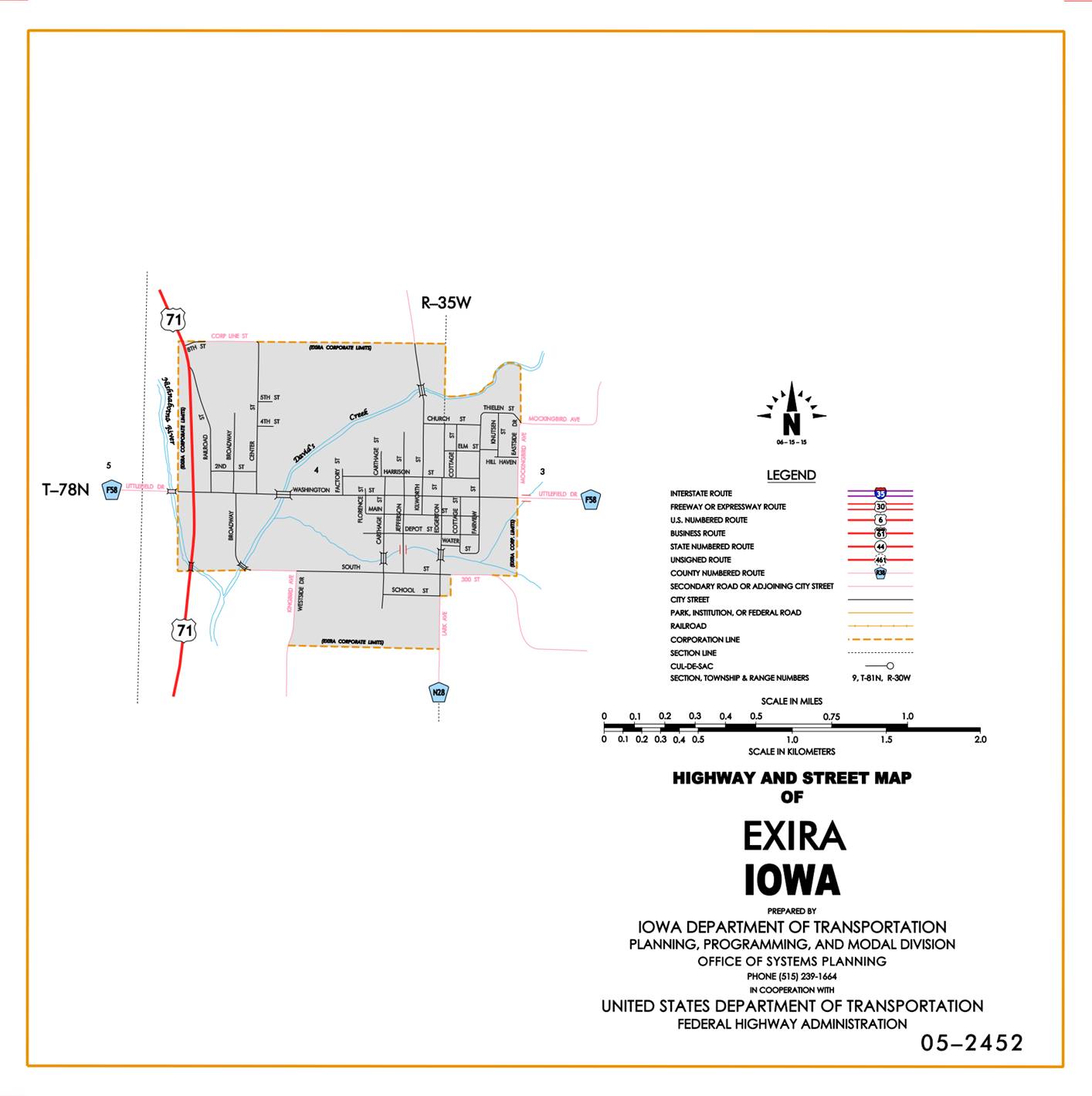
Exira:
Beginning
on the south corporation line; thence northerly to the north corporation line.
Beginning
again on the north corporation line of Exira; thence in a northerly direction
through Section 4‑T78N‑R35W and Section 35‑T79N‑R35W to
a point approximately 1,000 feet south of the NW Corner Section 35‑T79N‑R35W;
thence north following substantially the section line of Sections 35, 26, 23,
and 14‑T79N‑R35W to a point approximately 500 feet south of the E ¼
Corner of Section 15‑T79N‑R35W; thence in a northwesterly direction
through Sections 15, 10 (junction Iowa 44), and 3‑T79N‑R35W; thence
continuing in a northwesterly direction through Sections 34, 33, and
28-T80N-R35W to the south corporation line of Audubon connecting with Market
Street.
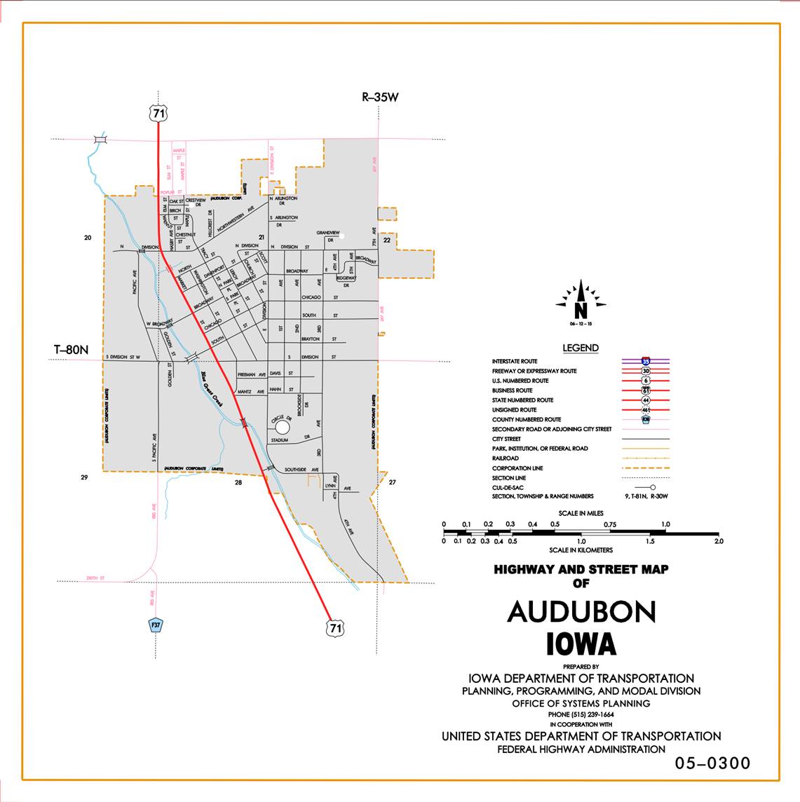
Audubon:
Beginning
on the south corporation line connecting with Market Street; thence
northwesterly to the west corporation line.
Beginning
again at the west corporation line of Audubon; thence northwesterly through
Section 28-T80N-R35W to the south corporation line of Audubon connecting with
Market Street.
Audubon:
Beginning
on the south corporation line connecting with Market Street; thence
northwesterly and northerly on Market Street to the north corporation line.
Beginning
again at the north corporation line of Audubon connecting with Market Street;
thence north following substantially the section line of Sections 21, and 16‑T80N‑R35W
to a point approximately 500 feet north of the W ¼ Corner of Section 16‑T80N-R35W;
thence in a northeasterly and northerly direction through said Section 16 to a
point approximately 300 feet east of the NW Corner of Section 16‑T80N‑R35W;
thence in a northerly and northwesterly direction through Section 9‑T80N‑R35W
to a point approximately 400 feet north of the W ¼ Corner of Section 9‑T80N‑F35W;
thence north following substantially the section line of Sections 9 and 4‑T80N-R35W
and Sections 33, 28, 21, 16, 9, and 4‑T81N‑R35W to the Audubon-Carroll
County line at a point near the NW Corner of Section 4‑T81N-R35W, Audubon
County (SW Corner of Section 33‑T82N‑R35W, Carroll County).
OFFICIAL DESCRIPTION CHANGE
COUNTY: Audubon
ROUTE: US 71
STAFF
ACTION NUMBER: S-87-688
APPROVAL
DATE: 12-18-86
New
Description ‑ US 71 and its extensions in
Beginning
on the Audubon‑Cass County line at a point approximately 600 feet east
of the SW Corner of Section 16‑T78N‑R36W, Audubon County (NW Corner
of Section 1‑T77N‑R36W, Cass County); thence in a northeasterly
direction through Sections 36, 25, and 24‑T78N‑R36W and Section 19‑T78N‑R35W
to the south corporation line of Brayton connecting with Lincoln Street.
Brayton:
Beginning
on the south corporation line connecting with
Beginning
again on the north corporation line of Brayton connecting with Lincoln Street;
thence in a northeasterly direction through Sections 19, 16, 17, 8, 5, and 4‑T78N‑R35W
to the south corporation line of Exira connecting with an unnamed street.
Exira:
Beginning
on the south corporation line connecting with an unnamed street; thence
northerly to the north corporation line connecting with an unnamed street.
Beginning
again on the north corporation line of Exira connecting with an unnamed street;
thence in a northerly direction through Section 4‑T78N‑R35W and
Section 35‑T79N‑R35W to a point approximately 1,000 feet south of
the NW Corner Section 35‑T79N‑R35W; thence north following
substantially the section line of Sections 35, 26, 23, and 14‑T79N‑R35W
to a point approximately 500 feet south of the E ¼ Corner of Section 15‑T79N‑R35W;
thence in a northwesterly direction through Sections 15, 10 (junction Iowa 44),
and 3‑T79N‑R35W; thence continuing in a northwesterly direction
through Sections 34, 33, and 28-T80N-R35W to the south corporation line of
Audubon connecting with Market Street.
Audubon:
Beginning
on the south corporation line connecting with Market Street; thence
northwesterly and northerly on Market Street to the north corporation line.
Beginning
again at the north corporation line of Audubon connecting with Market Street;
thence north following substantially the section line of Sections 21, and 16‑T80N‑R35W
to a point approximately 500 feet north of the W ¼ Corner of Section 16‑T80N-R35W;
thence in a northeasterly and northerly direction through said Section 16 to a
point approximately 300 feet east of the NW Corner of Section 16‑T80N‑R35W;
thence in a northerly and northwesterly direction through Section 9‑T80N‑R35W
to a point approximately 400 feet north of the W ¼ Corner of Section 9‑T80N‑F35W;
thence north following substantially the section line of Sections 9 and 4‑T80N-R35W
and Sections 33, 28, 21, 16, 9, and 4‑T81N‑R35W to the Audubon-Carroll
County line at a point near the NW Corner of Section 4‑T81N-R35W, Audubon
County (SW Corner of Section 33‑T82N‑R35W, Carroll County).
COMMISSION ORDER
DIVISION: Planning & Research
COMMISSION
ORDER NUMBER:
PR-79-272
SUBMITTED
BY: C. I. MacGillivray
MEETING
DATE: 11-2-78
DISCUSSION/BACKGROUND:
Due
to a review of our Primary Road System Records, US 71 in Audubon County should
be deleted and the new description added should be officially included into the
Primary System.
PROPOSAL/ACTION
RECOMMENDATION:
It
is recommended that the old description of US 71 in Audubon County be deleted
and the new description, as referred in the attached detailed description, be
included in the Primary Road System effective upon the adoption of this
resolution.
Locate
US 71 and its extensions in
Beginning
on the Audubon‑Cass County line at a point approximately 600 feet east of
the SW Corner of Section 36‑T78N‑R36W, Audubon County (NW Corner of
Section 1‑T77W‑R36W, Cass County); thence in a northeasterly
direction along the west side of the Chicago, Rock Island and Pacific Railway
and substantially parallel thereto through Sections 36, 25, and 24-T78N-R36W
and Section 19‑T78N‑R35W to the south corporation line of the City
of Brayton connecting with an unnamed street.
Brayton:
Beginning on the south corporation line connecting with
an unnamed street; thence northeasterly, northerly, and northeasterly to the
north corporation line connecting with an unnamed street.
Beginning
again on the north corporation line of the City of Brayton connecting with an
unnamed street on the west side of the Chicago, Rock Island and Pacific
Railway; thence in a northeasterly direction along the west side of said
railroad and substantially parallel thereto through Sections 19, 18, 17, 8, 5,
and 4‑T78N‑R35W to the south corporation line of the City of Exira
connecting with an unnamed street.
Exira:
Beginning
on the south corporation line connecting with an unnamed street; thence
northerly to the north corporation line connecting with an unnamed street.
Beginning
again on the north corporation line of the City of Exira connecting with an
unnamed street on the east side of the Chicago, Rock Island and Pacific
Railway; thence in a northerly direction along the east side of said railway
and substantially parallel thereto through Section 4‑T73N‑R35W and
Section 35‑T79N‑R35W to a point approximately 1000 feet south of
the NW Corner of Section 35‑T79N‑R35W; thence north following
substantially the section line of Sections 35, 26, 23, and 14‑T79N‑R35W
to a point approximately 500 feet south of the E ¼ Corner of Section 15‑T79N‑R35W;
thence in a northwesterly direction through Sections 15, 10 (junction Iowa 44),
and 3‑T79N‑R35W; thence continuing in a northwesterly direction
through Sections 34, 33, and 28‑T80N‑R35W to the south corporation
line of the City of Audubon connecting with an unnamed street.
Audubon:
Beginning on the south corporation line connecting with
an unnamed street; thence northwesterly and northerly to the north corporation
line connecting with an unnamed street.
Beginning
again at the north corporation line of the City of Audubon connecting with an
unnamed street; thence north following substantially the section line of
Sections 21 and 16 to a point approximately 500 feet north of the W ¼ Corner of
Section 16‑T80N‑R35W; thence in a northeasterly and northerly
direction through said Section 16 to a point approximately 300 feet east of the
NW Corner of Section 16‑T80N‑R35W; thence in a northerly and
northwesterly direction through Section 9‑T80N‑R35W to a point
approximately 400 feet north of the W ¼ Corner of Section 9‑T80N‑R35W;
thence north following substantially the section line of Sections 9 and 4‑T80N‑R35W
and Sections 33, 28, 21, 16, 9, and 4‑T81N‑R35W to the Audubon‑Carroll
County line at a point near the NW Corner of Section 4‑T81N‑R35W,
Audubon County (SW Corner of Section 33‑T82N‑R35W, Carroll County).
REVISED: 12-18-86
COMMISSION
ORDER
DIVISION: Planning & Research
COMMISSION
ORDER NUMBER:
PR-76-490
SUBMITTED
BY: Raymond L. Kassel
MEETING
DATE: 4-20-76
DISCUSSION/BACKGROUND:
Due to the review of our Primary Road System records, US
71 in Audubon County should be deleted and the new description added should be
officially included into the Primary System.
PROPOSAL/ACTION
RECOMMENDATION:
Locate
US 71 in Audubon County,
Beginning on the Audubon‑Cass‑County line at
a point approximately 600 feet east of the SW Corner of Section 36‑T78N‑R36W,
Audubon County (NW Corner of Section 1‑T77W‑R36W, Cass County);
thence in a northeasterly direction along the west side of the Chicago, Rock
Island and Pacific Railway and substantially parallel thereto through Sections
36, 25 and 24-T78N-R36W and Section 19‑T78N‑R35W to the south
corporation line of the City of Brayton connecting with an unnamed street.
Beginning
again on the north corporation line of the City of Brayton connecting with an
unnamed street on the west side of the Chicago, Rock Island and Pacific
Railway; thence in a northeasterly direction along the west side of said
railroad and substantially parallel thereto through Sections 18, 17, 8, 5 and 4‑T78N‑R35W
to the south corporation line of the City of Exira connecting with an unnamed
street.
Beginning
again on the north corporation line of the City of Exira connecting with an
unnamed street on the east side of the Chicago, Rock Island and Pacific Railway;
thence in a northerly direction along the east side of said railway and
substantially parallel thereto through Section 4‑T78N‑R35W and
Section 35‑T79N‑R35W to a point approximately 1000 feet south of
the NW Corner of Section 35‑T79N‑R35W; thence north following substantially
the section line of Sections 35, 26, 23 and 14‑T79N‑R35W to a point
approximately 500 feet south of the E ¼ Corner of Section 15‑T79N‑R35W
thence in a northwesterly direction through Sections 15, 10, and 3‑T79N‑R35W;
thence continuing in a northwesterly direction through Sections 34, 33, and 28‑T80N‑R35W
to the south corporation line of the City of Audubon connecting with an unnamed
street.
Beginning
again at the north corporation line of the City of Audubon connecting with an
unnamed street; thence north following substantially the section line of
Sections 21 and 16 to a point approximately 500 feet north of the W ¼ Corner of
Section 16‑T80N‑R35W; thence in a northeasterly and northerly
direction to a point approximately 300 feet east of the NW Corner of Section
16-T80N‑R35W; thence in a northerly and northwesterly direction to a
point approximately 400 feet north of the W ¼ Corner of Section 9‑T80N‑R35W;
thence north following substantially the section line of Sections 9 and 4‑T80N‑R35W
continuing north along the section line of Sections 33, 28, 21, 16, 9 and 4‑T81N-R35W
to the Audubon‑Carroll County line at a point near the NW Corner of
Section 4‑T81N‑R35W, Audubon County (SW Corner of Section 33‑T82N‑R55W,
Carroll County).
NOW,
THEREFORE: Be it resolved that the Iowa Department of Transportation approve
the location of US 71 in Audubon County,
NOTE:
To become effective upon adoption of this resolution.
OFFICIAL
DESCRIPTION CHANGE
COUNTY: Audubon
ROUTE: US 71
APPROVAL
DATE: 4-14-37
Beginning
on the Audubon‑Cass County line at a point approximately 600 feet east of
the SW Corner of Section 36‑T78N-R36W, Audubon County (NW Corner of
Section 1‑T77N-R36W, Cass County); thence in a northeasterly direction
along the west side of the Chicago, Rock Island and Pacific Railway and
substantially parallel thereto through Section 36, 25, and 24‑T78N-R36W
and Section 19‑T78N-R35W to the south corporation line of the Town of
Brayton connecting with an unnamed street.
Beginning
again on the north corporation line of the Town of Brayton connecting with an
unnamed street on the west side of the Chicago, Rock Island and Pacific Railway
thence in a northeasterly direction along the west side of said railroad and
substantially parallel thereto through Section 18, 17, 8, 5 and 4‑T78N-R35W,
to the south corporation line of the Town of Exira connecting with an unnamed
street.
Beginning
again on the north corporation line of the Town of Exira connecting with an
unnamed street on the east side of the Chicago, Rock Island and Pacific Railway
thence in a northerly direction along the east side of said railway and
substantially parallel thereto through Section 4‑T78N-R35W, and Section
35‑T79N-R35W, to a point approximately 1000 feet south of the NW Corner
of Section 35‑T79N-R35W; thence north following substantially the
section line to a point approximately 500 feet south of the E ¼ Corner of
Section 15‑T79N-R35W thence in a northwesterly direction to a point
approximately 700 feet west of the NE Corner of Section 15‑T79N-R35W;
thence in a northwesterly direction along the east side of the Chicago, Rock
Island and Pacific Railway and substantially parallel thereto to a point
approximately 1000 feet north and 400 feet east of the center of Section 10‑T79N-R35W;
thence crossing to the west side of said railway and continuing in a
northwesterly direction along the west side of said railway and substantially
parallel thereto through Section 10 and 3‑T79N-R35W, and Section 34, 33
and 28‑T80N-R35W, to the south corporation line of the City of Audubon
connecting with an unnamed street.
Beginning
again on the north corporation line of the City of Audubon connecting with an
unnamed street; thence north following substantially the section line to a
point approximately 500 feet north of the W ¼ Corner of Section 16-T80N-R35W;
thence in a northeasterly and northerly direction to a point approximately 300
feet east of the NW Corner of Section 16‑T80N-R35W; thence in a northerly
and northwesterly direction to a point approximately 400 feet north of the W ¼
Corner of Section 9‑T80N-R35W; thence north following substantially the
section line to the Audubon‑Carroll County line at a point near the NW
Corner of Section 4‑T81N-R35W, Audubon County (SW Corner of Section 33‑T82N-R35W,
Carroll County).
Beginning
at a point approximately 1500 feet west of the E ¼ Cor. of Sec. 10-T79-R35,
thence curving in a northwesterly direction to a point approximately 1800 feet
west and 200 feet north of the E ¼ Cor. of Sec. 10-T79-R35.
Beginning
at a point approximately 1500 feet west of the E ¼ Cor. of Sec. 10-T79-R35,
thence curving in a southwesterly direction to a point approximately 1700 feet
west and 200 feet south of the E ¼ Cor. of Sec. 10-T79-R35.
OFFICIAL
DESCRIPTION CHANGE
COUNTY: Audubon
CITY
OF: Exira
ROUTE: US 71
APPROVAL
DATE: 2-5-36
Commencing
on unnamed street at the south corporation line on the west side of the
Chicago, Rock Island and Pacific Railway; thence northerly on unnamed street
crossing the Chicago, Rock Island and Pacific Railway to the north corporation
line to a point on the east side of said railroad.
OFFICIAL
DESCRIPTION CHANGE
COUNTY: Audubon
CITY
OF:
Brayton
ROUTE: US 71
APPROVAL
DATE: 2-5-36
Commencing
on unnamed street at the south corporation line on the west side of the
Chicago, Rock Island and Pacific Railway; thence northeasterly on unnamed
street to Lincoln Street; thence northerly on Lincoln Street to Broadway;
thence northeasterly on unnamed street to the north corporation line.
OFFICIAL
DESCRIPTION CHANGE
COUNTY: Audubon
CITY
OF:
Audubon
ROUTE: US 71
APPROVAL
DATE: 2-5-36
Commencing
on an unnamed street at the south corporation line; thence northwesterly on
unnamed street to